


- Politics
- Diversity, equity and inclusion
- Financial Decision Making
- Telehealth
- Patient Experience
- Leadership
- Point of Care Tools
- Product Solutions
- Management
- Technology
- Healthcare Transformation
- Data + Technology
- Safer Hospitals
- Business
- Providers in Practice
- Mergers and Acquisitions
- AI & Data Analytics
- Cybersecurity
- Interoperability & EHRs
- Medical Devices
- Pop Health Tech
- Precision Medicine
- Virtual Care
- Health equity
Google Street View Cars Take on Public Health by Assessing Air Quality in Amsterdam
Launched in 2014, Project Air View is designed to help people react to unhealthy environmental conditions.


Photo/thumb have been modified. Courtesy of Google.
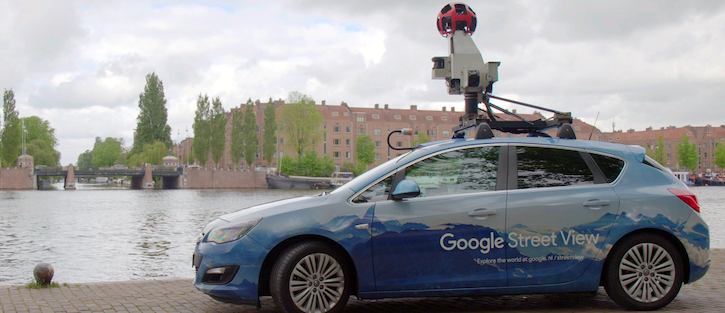
Street View cars are measuring the air quality at several points around Amsterdam to show a more detailed street-by-street picture of the city’s air quality, according to an announcement today from Google Earth Outreach.
The latest incarnation of an initiative named Project Air View, the effort could have implications for public health, alerting people of poor air quality and how to respond. In Amsterdam, a city where bicycles make up more than a quarter of the traffic, pollution still cuts the average life span by a year.
“Our hope is that small changes like this can help improve overall quality of life,” wrote Karin Tuxen-Bettman, program manager of Google Earth Outreach.
Two Street View cars with air sensors measure nitric oxide, nitrogen dioxide, ultra-fine dust and soot.
Scientists from Utrecht University are working with the municipality and Google to plan the driving routes and lead the data validation and analysis.
Once the data are analyzed and validated, Google Earth Outreach will share insights with the public to help people make more informed decisions about how to manage bad air quality. Tuxen-Bettman wrote that if the research shows differences in air quality between certain areas in the city, people could adjust their bicycle route or exercise at a different time.
Amsterdam is not the first city to be equipped with Street View cars to measure air quality.
Project Air View launched in 2014 when Google Earth Outreach and the Environmental Defense Fund partnered to map methane leaks under U.S. city streets using Street View cars.
The initiative helped detect a diverse mix of pollutants in Oakland and Houston.
In Copenhagen and London, Street View cars also measure air quality.
But this is just one component of Google’s public health work.
In 2008, Google Flu Trends developed “nowcasting” to surveil internet postings for signs of flu outbreaks.
Although the company discontinued the effort, researchers from Columbia University developed their own model, which uses flu-like illness data at the state level and web-based search activity from Google Extended Trends.
The researchers found they could more accurately assess states with larger populations.
So what’s the hope for public health initiatives such as Google’s Project Air View? That it might give individuals more of a say in their health and provide actionable insights that can lead to better outcomes.
Get the best insights in digital health directly to your inbox.
Related
Why Cellphones Might Be the Next Great Public Health Tool
Anti-Vaxxers Thrive on Social Media. Here's How Healthcare Must Respond.
How Health Tech Affects Cancer Patients in Minority Populations


